 The Double Dare is Eric’s insane double version of the Pisgah Mountain Bike Adventure Race. To keep it short, it is basically and all day suffer fest for two days in a row. There are 10 checkpoints each day and 12 hours in which to nab those checkpoints on each day. Luckily Joe and I had decided to keep the “competition level” at an all time low.
This would end up being the smartest decision we had ever made. Earlier in the week I had a serious case of sinus pressure and just generally feeling bad. On Friday, I had the joy of moving and luckily I had an unlucky volunteer. THANKS BRAD!!!!!
I decided to drive up Saturday morning so I could spend a night in my new house before the race. The day was perfect with cool temperatures and bluebird skies.
I still felt like crap and wondered if I was going to have any energy for the first day. Eric told us that we would be “time trialing” to the top of Farlow from White Pines Campground. Then we would “start the race” by receiving our passports with all the ten checkpoints including a mandatory checkpoint.
I felt ok climbing to Farlow even though it is one of the hardest gravel grinders in all of Pisgah. I walked a little and tried to enjoy the views of Looking Glass when I could.
Once we made it to Farlow we looked at the passport and the mandatory checkpoint was up at Ivestor Gap, a place I had never been.
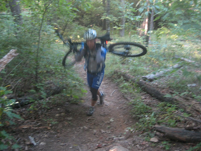
We quickly realized that the fastest route to Ivestor was by hiking the Art Loeb trail to the Parkway. It was a nice long steep walk. It was the kind of walk where you get to know yourself and how much your bike weighs.
I was a little confused as the map showed Ivestor Gap Trail as closed to Bikes. I was hoping this was the right trail and the best way to get to the “Shining Rock Wilderness” because that was the actual checkpoint.

So now we have been on the bike for over three hours and we have gone downhill 0 miles. We rode up the Parkway and up 818 and up Ivestor Gap. Later when I would talk to Eric I would find out that we topped out very close to 6,000 feet at one point on Ivestor. For the East Coast, that is a pretty big elevation number.
Once we made it to Ivestor, I was a wreck. Every rock I would pedal over was like a shock to the brain. I couldn’t muster up a speed over 5mph.

I must have even looked worse than I felt because Broussard was manning the checkpoint and offered me a ride back to the campground. I happily declined and drank a vanilla coke and two beers.
I contemplated and contemplated which way we would go back. Eventually I decided the best route was exactly the way we came.
Ivestor Gap --> 818 --> BRP --> Art Loeb --> Farlow --> Daniel Ridge --> Davidson River --> 475 --> 276 --> 476

That was a big day and we only got two checkpoints, dammmmmmmmmmmmn. I am glad we weren’t “competing.”
Day Number Two:
I heard Eric rolling around the campground ringing the cowbell. It was waaaaaay to early and even though I heard my name, I had to lay there. Eventually I got up and made
 my way over to the fire. I approach Eric and he gets in my face asking if we are going or not. Reluctantly we went and suited up for the day. We had made a vow “no matter what course the race dictates, we are going on single track.”
Eric informed us that we were to head to Yellow Gap to get our passports. However, since we were late, he gave us passports that were not to be looked at until we got to the gap. So I told Joe the fastest way to the gap was on Forest Service Roads but we had vowed for Single Track. So this was our route to yellow gap:

476 --> Clawhammer --> Maxwell Cove --> Black Mountain --> Turkey Pen --> 66 Jumps --> SMR --> Mullinax --> Laurel Creek --> Bradley Creek --> 5015
Turkey Pen was a blast, Joe tried to count the gaps but got confused along the way. I just plodded on forward as I was feeling much better. I think I had finally hit the apex of my cold. I burped some air out of my back tire and quickly realized I had three dud CO2’s with me. How that happens I don’t know, I borrowed a canister from Joe and got the tire rolling again.

Once we finally made it to Yellow gap I sat down and looked at the passport. The mandatory checkpoint was back close to South Mills River and Mullinax. HA! I figured we were going by checkpoints but it didn’t matter as we were just out for a long single track day. So after we decided to ditch all the checkpoints I came up with the following route to get us home:
1206 --> 476 --> 5018 --> Horse Cove Gap --> Squirrel Gap --> South Mills River --> Buckhorn Gap --> Black Mountain --> Maxwell Cove
Joe had no idea what I had in store and probably would have called a cab off of 1206 had he known.
As I was climbing 1206 headed for 476 I came across a little scene. A motocross rider had careened off of the gravel road and down into the mountain laurel. There was an elderly couple there trying to help him out. I stopped and when I looked at his bike down in the laurel I wondered how we made it out unscathed.

Eventually some more people showed up and with the help of three guys and a little towing we had him back on his way.
Horse Cove and Squirrel were a blast. I felt great and was really feeling the single track. I had never gone from SMR to Buckhorn up to Black Mountain that way before so I made the right turn onto SMR
 and figured I was going the correct way. Joe started making “take me home ASAP” comments and I started to question my directional ability.
Climbing SMR I came up on two hikers. They asked if I knew the way to the parking lot. Uhhhhhhhhhhhh, which parking lot? They said “Wolf Ford, Ummm I mean Pink Beds, yeah that is it up by the Pink Beds.” I asked if they had a map? Of course they didn’t and they guy told me “I had knee surgery two weeks ago.” My sweet Jesus I thought but all I said was “That is bad. . . “
So I started explaining that they needed to go back the way the came and I pointed up the trail the way I was heading and said “You came from that way right?” They said yes and so I told them the fastest way was to backtrack. Then Joe pulled up and I asked them if they wanted me to alert anyone up ahead for assistance. He said No and I asked if they had water, he said yes so I let it be. However, as we pulled away they started walking down SMR.. . WTF??????

Now I was losing my mind because I didn’t know who was losing their mind. Was I headed in the wrong direction or was that guy and his girlfriend delirious on where the car was, where they were, where they had came from? I started to second guess myself but calmed my nerves down by thinking that if we were truly headed down SMR in the wrong direction we would start crossing the river and the trail would look familiar to me.
Eventually I made it to Buckhorn gap and as I waited for Joe, I wondered what the hikers fate would be.
 After the short climb up Buckhorn, I declared to Joe that I wanted to go up Black Mountain since we had come this far. He refused and took off down clawhammer so I made the hike myself. I always forget how many false summits that bad boy has but it is all so worth it. That was one heck of a route! Congrats to all those who went out and soldiered through!
Great format Eric! I hope to come back next year and put in a little more effort in competing!

4 comments:
The drill Sargent says 'Time to GO!' 'You Racin' or You Sittin'?'
:)
I hope I wasn't too up in your face... you know... It was time for you to GO!
Thanks for coming out Jonathon. I hope your new house is treating you well.
~E
E,
You were all good, I told Joe later "If it were my race, I probably would have kicked my @$$.
"
Dude, Time Trialing to the top of Farlow? Then Hiking the Art Loeb. After moving into your new home. Great sloggin through it. By far sounds like the toughest Double Dare to date. May have to get me a piece next year.
Congrats on pushing through that much. That sounds brutal, especially when you were moving the previous day.
Post a Comment