Tuesday, January 29, 2008

Ode To Damon's Machine

Late Edit: I almost forgot. If you ride Dupont, check it out and go add your input.


This sweet sweet niner met its ultimate death after the ride this past Sunday. Apparently the same truck that safely transported my faulted Drunken Monkey to the shop decided the Niner was no longer needed in Damon’s life and expunged the orange rocket from the roof rack at 77 mph down the highway. After a quick show of somersaults and flips she was smashed by three other cars. I snapped the picture above Sunday before she passed. . .

Icycle!!

Monday, January 28, 2008

Lynch’s Turkey Wine Modoc Lick Fork

It was nice to set the wheels down on firm ground this weekend and actually feel them roll! As I knew the north would be flooded with melting snow, it was time to head into the heartland of South Carolina.

Saturday was a good two laps at Lynch’s with Goat Master, Shade, BrouSSard and Harlee. Not much to report besides that the trails are in perfect shape right now and the trail is easy to spot. The only thing notable was this tired poopers:

Saturday was a different story altogether. I was up by 5:30 so I could meet Zach and Andrew for our carpool to Lick Fork State Park in the western part of South Carolina. The propagator of FATS (Forks Area Trail System) was holding a fundraiser ride for the phase III plans for FATS. For a suggested retail donation of $25.00 you got a map and a jeep to carry some SAG supplies to the halfway point of 28 miles.

I had ridden all of these trails before so I knew what to expect, I just wasn’t sure how the gravel to connect them would pan out. It was put together very nicely and the map didn’t skip a beat. Well some people thought it did but they don’t count 8-)

Bill gave a short speech on what to look for on the course as he had marked some spots of pavement and tree flags. Then he said we could go and I heard someone in our group say “Well we should go get out front.” That was all I needed to hear as the first six miles were all single track at Lick fork and I remembered loving that trail. I hopped out in the lead and proceeded to keep all pistons firing until the six miles was done. One of my favorite downhills in SC is along that trail and I pinned it going down hooting and hollering with a trail of riders behind me.

This was also my biggest mistake of the day as my legs would feel like concrete for the rest of the day but it didn’t matter as temps jumped into the 50’s pretty quickly and we all just spun along the road. Every now and then I would find myself trying to paceline with the gearies as I was running 34X19 and able to keep pace if I really pushed the RPM’s but that was a recipe for disaster if I tried to hang longer than a minute.

There was some confusion at the first big turn but it was quickly cleared up by me and I was happy to be in front of my geared friends for a couple minutes longer. Toby was out rocking the ghettofied 69’er:

Turkey and Wine have always held a special place in my MTB heart and yesterday was no exception. How could you not enjoy a thin ribbon of trail that takes you from county to county for 18-20 miles. The trail is no wider than one hand with twists, turns, swooping canal ditches and a few small climbs and descents. All of this while cruising easily above 10 mph amongst the trees is more than enough to make you wear a smile if even your friends will only let you catch your breath for 2.8 seconds.

Modoc was everything I remembered her to be with the fast flowing ridgeline sections and the tricky creek crossings. I started to get my legs back a little on this trail as I started to realize the ride was almost over.

A great 50+ miles on a fantastic day for a fantastic cause, more mountain bike trails! Our group hammered out the 50 in less than five hours, nice work, can’t wait to do it again.

Wednesday, January 23, 2008

Bike-Ski

This weekend was so incredible in my eyes I just had to split it into two posts. Sunday night after Desolate Peas-Gah, I thought I would never want to venture into the cold again. It took me a good while to warm up sitting directly in front of the blazing fire before I was warm again. The experience was behind me and it taught me a lot about the upcoming race and what South Carolina has done to my tolerance of the cold.

Hypothermia should be on the forefront of everyone’s minds if you are attempting this race. Special plans and circumstance will have to be taken to avoid getting wet AT ALL COSTS. This is no joking matter, we will be in the dark, all alone, in the wilderness with only ourselves to rely on. Imagine, after only 9 hours how cold I was; because once the chill gets into your inner core it is close to impossible to relieve. In the race format, I would still have another 27 hours to go. Hot meals are going to be a requirement when we make it back to base camp during the race. These are the thoughts I had while warming from Saturday’s adventure.

Sunday was a day of reflection and rest.

Monday brought on another un-expected snow adventure. Shade, Obi, Kristin, Andrew, David George and I all met up at Fawn Lake for some more fun in the snow. Once again, I never expected there to be so much snow left from Wednesday’s storm. We took the dogs out on a “short loop” that ended up being pretty long from snow resistance.

Reasonover -> Lake Julia Road -> Shelter Rock -> Airstrip -> Fawn Lake

Monday’s snow riding was slightly different than Saturday’s because the snow was frosted over from a cold, cold night. So the surface of the snow provided a gentle coaxing surface that led you to believe you would just glide gracefully over the top until you made a sudden movement and you would hear the sound of the crystals tearing apart and your wheels sinking deeply into the snow causing you to increase your power to maximum thresh hold.

It was a fine Taoistic balance of quiet movements and speed that allowed your bike to glide gracefully over the surface. This was of course riding flat or uphill. Going down on this day was all fun fun fun! The first downhill was Reasonover and I took off as fast as I could go thinking the conditions would be like Sunday. That is the best part about snow though as the trail is in a constant state of flux from sunlight, heat pockets and shade.

So flying down the trail able to maneuver the bike into the deeper patches I was able to rocket down the trail in an uncontrollable slide. I had no breaks to speak of and so I just went with it. I went down pretty hard on the first descent and came up laughing. Once you went down, you just slid and slid. I actually think for the first time ever (that I have seen) there was a falling hazard in the mountains. If you fell on a steep slope that was this slippery, only an ice axe could slow you down, well that or a tree.

So it was with great joy that we came all the way down Reasonover. Shade loves the snow and his toleration of cold temps has me very worried for the summer. He has no problems wading in water that is below freezing.

After the short dog loop, Andrew and I headed back out for some more fun:

Fawn Lake -> Airstrip -> Barn Trail -> Bridal Veil Falls Road -> Corn Mill Shoals -> Laurel Ridge -> Mine Mountain

Bridal veil was looking great. Once side was frozen with snow and the actual falls side was flowing with heavy whitewater.

It was later in the evening coming down Mine Mountain and I noticed at the first tree that the snow looked funny. It had that yellow icy tint just like an early morning spring skiing slope. The snow had turned to glare ice and I barely kept it together across the slick section. I yelled back to Andrew but he didn’t heed the warning fast enough and went down with a Mike Tyson thud. I cringed as I caught the end of the fall as I turned around. I fell over and over again pressing the edge of speed for the conditions.


Tuesday, January 22, 2008

Desolate Peas-GAH


Its not very often that mother nature waves her wand in the right manner for snowy conditions in the Appalachian Mountains. Donning all my cold winter gear, including ski goggles, gloves and a slew of other safety equipment I met up with, ZB, Valerie, Clay and Dennis this past Saturday for an all day sloth through the mountains of Western North Carolina.

Even if we don’t like to formulate expectations in our minds, they will still creep into our subconscious and lead us astray. In this same manner, I expected there to be snow on the ground in the higher elevations on Saturday. As I was driving to the trails, the mountains had a very “out west” feel to them as they were gleaming white even with the sullen grey skies that loomed overhead.

Everyone wanted to know what the plan for the day was, I hadn’t thought about it much besides the fact that I wanted to be out all day. So we started traditionally by climbing from N. Mills River up 5000 to Wash Creek Road, up the gravel road to the top of Bear Branch. When we hit the turn to go up to Bear Branch, I knew it was not going to be a normal day. Getting the bike to go up a slope in four inches of frozen snow takes more than twice the effort as normal.

Snow sports have always been my favorite recreational activity. The snow puts off such an energy and that energy turns to synergy when you go out and play in it. Coming down Bear Branch was rad, yes I said rad. The snow made this incredible ripping sound as the crystals that you rode over tore apart from the surface. We were making fresh tracks and loving every minute of it.

After our glee from Bear Branch resided, we decided to take Wash Creek Road all they way to the top of the Parkway since the trails were so hard to go up. Plus I had something EVIL in mind. So up the road we went. The road had snow and ice on it but you could avoid the hard pedaling in the car ruts. I was telling a story to Dennis, Zach and Clay when I hit some ice chunks and promptly fell over going uphill almost taking Dennis out at the same time. I am sure at least one person laughed.

We knew the parkway would be closed and what a wonderful time when it is:

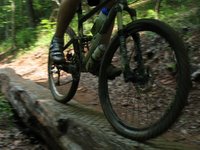
From there we traveled up through the tunnels of the parkway to the top of Trace Ridge. Trace was untracked and ready for our taking. Coming down a steep slope on frozen snow is different than any biking I had ever done. It takes on an entire new learning curve and forces you to forget what you already know about riding dirt. The front brake is virtually useless unless you want your front wheel to breakthrough the top layer of snow and have your bike come to a screeching halt. The back brake only works if you have broken through the top layer or it becomes a “commence rubber skating” lever by your right hand’s fingertips. Therefore, I quickly learned that the only feasible way to slow down was just like skiing. If you want to go slower, get into the deeper snow and let the friction of the snow slow you down.

So this is how we descended Trace, a wicked sliding, riding fiasco that drove everyone to pronounce their love for the outdoors. Unbeknown to us, desolation Pisgah was soon to freeze our smiles in place.

Big Creek was looming and Clay agreed that we should indeed hike up the beast on this day. This is no joke, and in the beginning we surmised how long it would take. Little did we know what lay ahead. I figured we would be able to ride the lower portion. It was slow going and took about four times the power normally necessary but we cut a path through the snow and lumbered our way to the steep section of Big Creek. I took a break and watched everyone (except for Valerie, she was smarter than the rest of us) march their way up the steeps. I had a lot of thoughts while I drug my bike up the snow. I started feeling very lethargic when I looked up and saw Clay. He was struggling to get a glove on a frozen hand so I stopped and helped. I had yet to get cold but some of the guys had taken a small foot plunge in the creeks at the bottom of the trail. I had fallen on the rocks pretty hard but avoided getting wet.

Once we got Clay’s glove back on, the sloth continued. Take a few steps, watch the bike try to slide and slip out of your grasp as the tires wouldn’t even roll on the frozen surface of the snow. Close to the top, the snow was around a ½ foot deep. I made it to the parkway and heard voices coming from the tunnel, it was my frozen comrades. I didn’t realize it at the time but we must have all looked like a bunch of crack heads up there in the tunnel trying to consume some calories and get warm:

My plan had been to descend Lauren Mountain after that incredibly difficult hike up Big Creek and our second ascension of the parkway. As I started to pedal up the parkway to the Pisgah Inn, I heard Zach yell “See ya dude.” So I went back down and talked to Dennis, they all were headed down the parkway back to Wash Creek Road and to the safety and warmth of the cars.

I couldn’t let it slip away, something drove me to want more. After all I was looking for an all day experience and it was only 3:00. I pedaled alone up to the inn. I stopped at one point just to take in the serenity and imagine how different this picture would be on a warm August day:

The last picture of the day was taken as I hiked up Pilot Rock from the Inn. I thought my hiking would be over soon as I would have some steep slopes to slide down soon. The snow continued to get deeper.

When I got to the Laurel Mountain connector I had a reality check. I would knock all the snow off my cleats while sitting on the bike and grasping a tree, clip in and shove off the tree as hard as I could. A couple times this resulted in a uncontrollable slide for ten feet or so, the rest of the time I just didn’t go anywhere. The snow was deep enough and frozen enough that even a 25 degree slope wasn’t steep enough for gravity to win over the snow. I was going to have to hike down now too.

Even though I was still relatively warm, thoughts of loneliness crept into my mind and threatened my ever decreasing will. My once over rambunctious joy of the snow had turned to a hatred. Laurel was hardly ever steep enough to ride and after going through all the necessary steps it took to get back on the bike I felt as though I was losing time every time I tried to ride.

It felt as though my tiredness was increasing at an exponential rate and I wondered if I would make it to 1206 before dark. That’s when I saw two other madmen out in the forest. I was about a 1/3 of the way down Laurel Mountain when I came across them. I can’t imagine how I looked to them but one said “Hey what’s the best way to North Mill’s River from here?” This confused me, I responded with “Where did you come from?” as they were obviously headed up the trail. They said “N. Mills River.” So I asked them if they had only come up Laurel, they said yes and wanted to know the quickest way back to the car. I wanted to laugh as I truly wanted a quicker way back to the car too. But instead I pushed on and told them the only way down was back the way they came.

This was inspiring, I had two fellow crack heads behind me wanting warmth just as bad as me. With a little luck, I was able to ride some of the bottom sections, when I went passed the meeting log I started to hold onto the hope that I might make it to the car before dark.

The guys passed me and told me they were in “survival mode.” I eventually made it to 1206, pedaled the very short distance to the top and then I knew all I had to survive was the 15 minute descent down the frozen gravel road to the car. I looked up at one of the switchbacks and saw the two guys loading their car. I thought about how nice warmth would be when I hit an ice patch and went sliding down the road. I just laughed at myself and re-mounted the bike. A few yards later I saw headlights coming up the road. It was Zach and Dennis about to form a beer party, oops I mean search party. I am grateful to have friends that are concerned.

Yes, I am labeling this one as, epic.

Peace


Friday, January 18, 2008

SCS Monkey


Do you hear something?

As most of you know my late bicycle’s name that my buddy donned her with was Drunken Monkey. I had an epiphany last night and figured that she broke because her hand was too close to the narcotics.

Therefore I have named my new Monkey, Stone Cold Sober Monkey.

I had some fun with pictures yesterday. I will caption them.


I wish I could carve turns like this!
Chillin'
My neighbor really knows how to let the kids have fun. When the sled would get to the corner Kenny would yell Hiyah Hiyah, the horse would take off and the sled would come whipping around the corner like a slalom skier.

Thursday, January 17, 2008

SC Snow

I really do love it when it snows in South Carolina. Somehow it just doesn’t seem right and even “other worldish.” Once while living in Charleston I saw snow on a palm tree, which was freaky.

The forecast was snow in the mountains starting around 6, so I figured we could still get a ride in, enjoy the sights and make it back in time to enjoy ourselves in the white stuff.

Dennis, Shade and I headed out with no particular plan in mind. Dennis had spoke with one of the rangers and another biker, they thought we were nuts but in all actuality it was the best time to be out as the ground was frozen and the trails were flying.

We ultimately completed the following loop:

Reasonover -> Lake Julia Road -> Shelter Rock -> Airstrip -> Laurel Mountain -> Corn Mill Shoals -> Shoals -> Laurel Ridge -> Airstrip -> Lake Julia Road -> Reasonover

It was Shade’s first full night ride and he had no problem keeping up in the dark. Dennis and I would stop for a second and there he would be trotting up after a few seconds. We both commented on how quickly he as gained strength and speed.

As the ride wore on I was concerned we wouldn’t get to see any snow. I had noticed my back tire going flat the day before and had pumped it up in the lot but tubeless was to no longer hold on my older Nevegal. Coming to the airstrip the second time my back wheel was too squishy so I stopped to put a tube in it.

As we came back up Reasonover it started precipitating a tiny bit, by the time we got to the top of the trail it was snowing. It was hard enough to make me squint to keep the flakes out of my eyes. I let Shade run in front of me and he was loving it. He was jumping up grabbing the flakes out of the air with his mouth. As always it created a Star Wars feel to the night.

When we got home there was a couple inches of powdery snow on the ground and Shade stayed outside frolicking in it for a couple hours before he wanted in. This morning the temps had warmed and the snow was too wet for fun. When I took Shade out he stepped in the snow as though his little princess feet couldn’t handle the slush. Its good to know he is a powder hound too!

Peace


Wednesday, January 16, 2008

Let It Snow

What is it about bike riding that decreases distances in our eyes? Four years ago, if I were to go and stand where my house now is, look at Paris the only mountain looming in the south and then tell myself I was going to ride a bike to the top, I would have laughed at myself.

Now as I pedal closer and closer to that rising plateau in the distance it seems so short by endurance cycling standards. That’s why I don’t mind pedaling with only one gear the entire way to the top.

Watching the sunset in the west, seeing the water tower loom close to my house where I was 40 minutes ago, I can see my shadow bouncing against the pink rays as I pound the pedals toward the pavement in a rhythmic dance with the black asphault. When you ride to the trails, it makes you appreciate the dirt ten fold once you lay your treads down in it.

I had corresponded with Rick earlier in the day and I knew that he would be headed up the mountain around 6. When I dropped in on Fire Tower, I saw somebody climbing the trail and asked them the time, five till six, perfect. I descended Firetower, rode up and down the techy section of Sulphur Springs and saw two riders coming up. It was Andrew and Rick, amazing timing.

It had been awhile since I rode in Paris and there is no doubt that absence makes the heart grow fonder. I missed the carved turns, rock outcroppings and roots so I made sure to say hello to all of them last night.

From there we rode down to the lake, around the lake loop twice, back up to Brissy Ridge, down to the backside, up the back road and up Firetower. This is where we broke off as Andrew and Rick headed back down the mountain to their cars and I sat and ate my trail mix, chatting with the misfit group (That’s your group’s name until you all start coming to SORBA meetings) about where I was headed. They thought I was crazy for riding from the house but in all actuality it only takes me 10 minutes longer going back by bike than car.

As I was headed out of the neighborhood, a young lady headed out for a run had a good laugh at me. I think she probably wondered why I would be out on the cold night riding with lights on top of my head. We exchanged pleasantries though, which was nice as it doesn’t happen often these days.

Flying down the backside of Paris was cold and pleasant at the same time. I could see all the lights down below and I knew I was headed back to a warm house and an excited dog.

Peace

Tuesday, January 15, 2008

Quickie

If you didn't know, most of the time when I post pictures you can click the picture to see the enlarged picture. The first picture I posted yesterday actually has a bike rider in it. Betcha all of you faithful readers didn't even realize that.

Tuesdays and Wednesdays are back on for night riding!! I will be trying to ride from the house on most Tuesdays and expect to be at the top of the mountain around 6:00 if you want to catch me.

Wednesdays meet @ 5:30, Fawn Lake for the best night ride eva eva eva!

Peace

Monday, January 14, 2008

Singletrack Hound


Saturday morning Shade and I headed to Dupont to check out some of the more sustainable trails there and to ride a bunch of gravel. I always knew I was partial to singletrack but I never figured I would find a dog that felt the same way.

Shade and I took off on the following loop:

Reasonover -> Turkey Gap -> Pinnacle Mountain Road -> Johanna Road -> Grassy Meadow -> Johanna Road -> Grassy Creek -> Sandy Trail -> Tarklin Branch -> Thomas Cemetery -> Buck Forest -> Sheep Mountain -> Pine Tree -> Longside -> Corn Mill Shoals -> Shoals -> Laurel Ridge -> Mine Mountain

The pack was frozen even with a 9:00 start and I tried to hit roads and trails that would be un-effected by all the rain we have seen.

I wasn’t sure if taking Shade that far was a good idea but after a little discussion we decided to try it. Shade kept up pretty well in the woods but out on the gravel he has no desire to run fast. When we came off of Pinnacle Mountain Road (an actual state road) onto Johanna Road (a rocky beast of a trail) I stopped and waited for Shade to catch up. I was going to let him make the decision of whether we were turning. As soon as he saw that we were headed back into the woods he took off on a beeline in front of me. I took off after him and as I caught him he took off into the woods and was running parallel to the trail in the woods dodging trees. It was great to be back on the bike.

As far as the new bike goes, it rides exactly like the Drunken Monkey and that means it is perfect. You can see in the following picture that Surly beefed up the downtube steer tube connection. This is exactly where my old one broke.

I was slightly worried about the river crossing on Corn Mill Shoals as I knew the water would be higher than I had seen it recently and I wasn’t sure if Shade would be reluctant to cross. I took off my shoes and walked in the frigid waters. When I got to the other side I called Shade and he started a little swim against the current. I wondered if he was alright until I realized he was lapping the water as he ice skated his way across the slippery rocks. Drinking on the go like a true cyclist.

I heard the call of my bike again early Sunday morning and rallied with David George at Fawn Lake. We set out for a 3 ½ hour ride similar to Saturday’s ride. I won’t name all the trails since I have uploaded the profiles. However, now that David has been “running the numbers” for awhile with his GPS. We found that we average about 1,000 feet of ascending for every hour on the bike in Dupont. Numbers are fun aren’t they?

Jim Branch isn’t even in my vocabulary these days as I have a new unsurpassed love for Ridgeline! Once again we stayed on the more sustainable trails and gravel roads since it was still a little soggy. Can we get a frozen pack please. . .

We stopped at the Sky Valley parking area for a quick tour of the kids loop and to grab a bite. There was only one van in the lot when we started eating. A horse trailer and truck pulled up into the lot and drove over every piece of gravel in the lot before they started backing into position. I was about to comment on how much they were driving around when we heard BOOM! They backed up right into the 50 foot telephone pole that is behind them in this picture. I had to walk into the woods I was laughing so hard.

I have lots of thoughts on TMHTE and Hypothermia. I will see if I can put them on paper sometime in the next few weeks.

Peace


Thursday, January 10, 2008

Undaunted Running

I have to take advantage of the forest no matter what way I am to enjoy it. So last night I gathered up Shade and my running shoes. Shade is starting to get used to my erratic driving and he knows when to sit up take a look and when it is best to lay down and hold on. The dog cracks me up all the time, I am sure he is telling me jokes sometimes.

When I arrived at Fawn Lake parking lot, BrouSSard was there prepping to ride his bike. Apparently he didn’t understand that it was a cross training night. I mean who wouldn’t want to run this route:

Fawn Lake -> Mine Mountain (Foot traffic only sections) -> Cart Trail -> Laurel Ridge -> Corn Mill Shoals (to Bridal Veil falls) -> Bridal Veil Road -> Barn Trail -> Shelter Rock -> Airstrip -> Fawn Lake Loop (counterclockwise)

Starting up Mine Mountain was tough and got my heart racing too quickly. Since I was on foot, I took the foot traffic only section of Mine Mountain. Before this trail was re-routed alongside of the peaks it was one of the most grueling trails in Dupont. It would take you up and over all the peaks instead of alongside them as the bike path now does. The foot traffic only trail is what it used to be and it is steep.

As I came to the top of Mine, the sun was setting and I knew I had made the right choice on my routes. I didn’t take a head lamp as I was pretty sure I could make it out by the light of whatever stars would be out and normally I am not too frightened of the dark especially when Shade Monster is on my side.

The cruise down to Bridal Veil was nice and my legs were warming nicely. It was nice to run at a brisk pace and not feel like my lungs were on fire. The funny part about it all is that I pick almost the same lines running as I do biking.

We stopped for a short break at Bridal Veil and Shade wanted to go swimming but I had to stop him. The falls had more water coming down it than I have seen in awhile, it was nice.

After the rest I started to get ambitious and wondered if I should just run all of Reasonover back to the car but after I ascended Airstrip I thought better of that. The last few inclines on Fawn Lake made me want to walk but I pushed through.

Hopefully my next story will be about bike riding as the new Monkey is almost ready. I am struggling with what I will call this new bike as it can’t have “Drunken Monkey.” Maybe Plastered Monkey, one too many Monkey . . . who knows but I will let the bike decide not me.

So I actually have some geeky bike stuff for everyone too look at too. I am changing a couple things on the bike just for funsies. I am getting a 34 tooth ring for the front so I calculated some ratios for comparison sakes last night:

These calculated ratios come from here.

Instead of giving you all the numbers I will explain it on non-single speeder’s terms. I mean everyone should understand Gear Inches anyway right?

So if I were using my normal mountain gear of 32X22 I would have the following techy numbers and remember this is calculated for 29” wheels (technically my wheels would be bigger than 29” because of the volume of the tire but we are only doing this for comparison sake):

32X22:

42.18 Gear Inches
132.52 inches of travel per pedal revolution

Now if I were to run 34X22 I would have:

44.82 Gear Inches
The increase percentage from 32 would be 6.25%
140.8 inches per pedal revolution

So if I were to only change the front ring I would travel 8 inches further with each pedal stroke and I would have to push 6.25% harder.

However, I ordered a 23 and a 24 from Marshall yesterday so let’s look at those numbers:

34X23:

42.87 Gear Inches (we see this is the closest I will get to my old mountain gear)
134.68 inches per pedal revolution

34X24:

41.08 Gear Inches
129.07 inches per pedal revolution

So this will be an even easier gear to push than what I currently have. Can you say supreme mountain climbing BABY!!!

So now that I have a plethora of cogs at my disposal 24 – 19, I can be ready for anything!! Except a track race of course. . .

Peace

Tuesday, January 08, 2008

Really, I don't Swing That Way

Check it out, yah that fine picture of Rich's @$$, I took it at Fool's Gold this past year whilst volunteering. I was actually running at the time of the picture as Rich was on a mission.

I have made millions on the picture and can now retire.

Peace

Monday, January 07, 2008

Another Weekend, Not Another Bike


Just because I don’t have a bike doesn’t mean that my preparation for TMHTE stops. Saturday I was able to rile David George and BrouSSard into going hiking with me. I wanted to make a long one and Zach had the idea of making a big loop from Jones Gap to Caesar’s Head. I had often wondered how long this would take as we would basically be covering the same elevation as 276 does on the way up to the park.

We headed out on Rim of The Gap and just past the connector trail (#22) we met up with two hikers coming down the direction we were headed up. The warned us that our dog better be “sure footed” as we had some pretty big ice patches to cross. I looked at some pictures they had and was admittedly a little scared for Shade but I figured we could turn back if it was too much.

Once you actually get on the ridgeline that gives “Rim of The Gap” trail its proper name, the trail turns into a rocky wonderland with wooden ladders, cable crossings and tight rock squeezes. We were literally surrounded by ice for a mile or more. You could see some spots where the water literally froze as it was moving and had created a hardened “bubble wrap” texture. Some of the icicles hanging from the upper region were as big around as my body and they loomed above us dripping. I wondered what the chances were that we could be impaled by Mother Nature. . .

It definitely did not feel like we were in South Carolina anymore. There were some tricky slick spots but for the most part I felt very safe having Shade with us. There was one wooden ladder that had a rung missing making impossible for Shade to scamper up the ladder on his own so I climbed to the top and David George and Zach lifted Shade up to the first un-broken rung and after I had him secured he climbed the rest of the ladder himself. From there on, all the ladders were intact and Shade would just scoot right up them after some encouragement by me.

We came within a mile of the Caesars’ Head visitors center before we descended back to Jones Gap. The easy walk back down Jones Gap Trial a.k.a. Jones Gap Highway was welcomed after our initial 2,000 foot ascension.

Profiles from Saturday’s Hike:

I figured I better shake the legs out on Sunday so I geared up for a minimalist trail run/hike at Jones Gap. Kristin took off toward the Jones Gap waterfall while I made an attempt to best my time to the overlook on Pinnacle Mountain. I started off with a brisk jogging pace up the mountain that quickly turned into a fast walk/hike. Then when the trail would level out just enough to run, I would run. I didn’t stop until I made it to the overlook and rested for five minutes before attempted to run back down. Coming down I was all over the place, lacking proper trail running shoes I was attempting the trail with my running shoes and when it got steep I could only stop by grabbing onto trees. Luckily I had brought my gloves with me. At one point I heard a large crash that I figured was ice breaking off of the steeps.

I made it around the 5 mile loop in just under two hours. It was the most physically demanding effort I have put down in long time.

Peace


Friday, January 04, 2008

Blog Stats for 2007

16,694 visits

28,114 page views

4,660 unique visitors

Top 10 referral sites:

FORUMS.MTBR.COM = 3,919

Direct (no referral) = 3,281

TEAMDICKY.BLOG.COM = 2,361

GOOGLE (Search Engine) = 913

ELWEVER.BLOG.COM = 634

PALMETTOSOLO.BLOGSPOT.COM = 563

BLOGGER.COM = 542

WWW2.BLOGGER.COM = 496

HARRELLSBICYCLEWORLD.BLOGSPOT.COM = 460

MTNGOATEPICS.COM = 418

Top referral search engine key words:

Extrmtao = 282

Riding in a zen manner extreme tomato = 122

Extrmtao fats = 41

Greenville mtbr = 27

Biking in a zen manner = 26

Most bizarre keywords that brought a referral:

Kwinky = 11

Counterfeit Pen Marks = 1

I have no muscles = 1

Nice rack Karate Monkey = 1 (I hope this isn’t what I think it is. . . )

Biking feels awesome = 1

Congaree Swamp Strange Animal sightings = 1

Drunken Monkey with feet for hands = 1 (This #$%& really is amazing to me)

Fat neighbor upstairs keeping me awake at night = 1

A total of 438 different search words brought people to this Blog in 2007.

Countries:

United States = 16,214

Canada = 106

United Kingdom = 65

Australia = 28

S. Korea = 17

New Zealand = 16

China = 16

Germany = 16

Netherlands = 14

Spain = 13

France = 13

Finland = 10

India = 8

Portugal = 7

Hong Kong = 6

Sweden = 6

S. Africa = 5

Italy = 5

Japan = 5

Four hits per country:

Austria

Israel

Ireland

Puerto Rico

Three hits per country:

Chile

Turkey

Thailand

Brazil

Poland

Malaysia

Romania

Philippines

Two hits for each country:

Serbia and Montenegro

Argentina

Russia

Colombia

Greece

All these countries had one hit a piece:

Czech Republic

Costa Rica

Mexico

Bahamas

United Arab Emirates

Singapore

Estonia

Switzerland

Belarus

Iran

Denmark

Croatia

Aruba

Lithuania

Hungary

Belgium

Iceland

Latvia

So there you have it folks. All I can say is that running Google analytics on your site for a year is good fun.

Peace

Thursday, January 03, 2008

Jonesin' For A Gap

I really could not have busted my frame at a better point in time. I don’t think too many have been making it out for rides in this winter wonderland we are having. Although I do miss the chance to don my snow gear and go for a ride.

I drug some friends up to the top of the Hospital Rock trail at Jones Gap last Saturday. It was an awesomely cloudy day that would eventually clear up.

New Year’s Eve we made it up to the gap again for a hike to the overlook.

Shade Monster finally poses for a picture!

Some nice clouds filled the valley early in the morning.
The Chapel at Pretty Place.

Chillin' at the overlook.
Frank a.k.a. I can find that ball no matter where you throw it. . .
For some, it was there first hike. Some techy spots out there as I don't like to hike where I could ride.
Steely Cool D.G. chillin' by Hospital Rock.
If you keep your eyes peeled, the forest is a grown man's jungle gym.


Notice the difference in technniques. Photo credit for the vine pictures goes to David George.