Of the trails that we dared ride for the WNDC yesterday evening, here is what I can report to you my reader.
Longside: Good condition, minimal impact from recent storms and currently dry.
Twixt: Increased ruts in spots, currently dry
Rock Quarry Road: Mostly clear, soft in spots
Buck Ridge Road: Clear, mostly dry
Micajah: Top rutted section is a disaster zone with increased rut damage from storms
Wilikie: Slick rock doesn’t erode good shape.
Big Rock: Very bottom is a rutted mess along with the normal wet spots, rest is good to go.
Cedar Rock Steep side: Same as Big Rock
Cedar Rock Long side: Good to go
Little River: Have you ever ridden it? Its wet.
Pine Tree: Good to go as Clay and I removed two sets of deadfall and it is dry.
Sheep Mountain: Good to Go
Isaac Heath and Locust: Good to Go
Thursday, January 28, 2010


Sunday, January 24, 2010
Pisgah Report
Finally for some recon, I got out for a dark night in Pisgah for some fun. I have been weary of the conditions in Pisgah after the snow storms and rain but when I read about the Friday night ride on MTBR I couldn’t resist.

I started my ride at 5:30 with a quick out and back on Coontree. I was surprised at the conditions on the bottom section as the trail was surprisingly dry.
Once I met up with Clay and Zach for our ‘warm-up’ on Farlow I realized that not all the conditions were superb. The roads are completely drenched and the ride up Pilot Mountain road was harder than I ever remember. It is a constant zig zag battle to figure out where the ground feels semi-ride-able. The roads just beg for you to get off and walk sucking every last bit of your energy.
On the double track over to the top of Farlow we found some leftover shin deep snow drifts. For a small section we hit the “disaster line” with trees down everywhere even though all of Farlow is clear.
I fell four times coming down Farlow, the hardest of them all happened while hiking down a steep section.
We met up with the rest of the group on Daniel and continued our loop:
276 -> 475 -> Davidson River -> 475 -> Pilot Mountain Road -> Farlow -> Daniel (counter clockwise, turn around at the bottom for a repeat) -> Cove Creek -> 225 -> 475 -> 276 -> 477 -> Bennett Gap -> Coontree

We rode from clear skies on Cove Creek into intense fog on 477. A great night with 8 hours logged in the woods.


I started my ride at 5:30 with a quick out and back on Coontree. I was surprised at the conditions on the bottom section as the trail was surprisingly dry.
Once I met up with Clay and Zach for our ‘warm-up’ on Farlow I realized that not all the conditions were superb. The roads are completely drenched and the ride up Pilot Mountain road was harder than I ever remember. It is a constant zig zag battle to figure out where the ground feels semi-ride-able. The roads just beg for you to get off and walk sucking every last bit of your energy.
On the double track over to the top of Farlow we found some leftover shin deep snow drifts. For a small section we hit the “disaster line” with trees down everywhere even though all of Farlow is clear.
I fell four times coming down Farlow, the hardest of them all happened while hiking down a steep section.
We met up with the rest of the group on Daniel and continued our loop:
276 -> 475 -> Davidson River -> 475 -> Pilot Mountain Road -> Farlow -> Daniel (counter clockwise, turn around at the bottom for a repeat) -> Cove Creek -> 225 -> 475 -> 276 -> 477 -> Bennett Gap -> Coontree

We rode from clear skies on Cove Creek into intense fog on 477. A great night with 8 hours logged in the woods.

Sunday, January 17, 2010
Gorges Biking
 As I was running next to Dennis while he spun the granny gear I said "You know why this is so hard? Because it isn't supossed to be Gorges Biking, its mountain biking."
Try riding your bike somewhere with "Gorges" in it and you will be in for some pain.
When you can't get a map this detailed anywhere, you take pictures of the map for consultation later. In the past two days I have logged close to 50 miles in Jocassee Gorges and I am sore.
Clay and I made the trip to Jumping off Rock on Friday and then a group of us made it back for a different route on Saturday.

Sunset on Jocasee from Jumping off Rock.

Clay prepares for the dark that is soon to come on the grueling 9 mile ride back to the trucks.

Saturday morning breakfast of champions for some unamed scandium rider.

We found some freshly graded roads, not all of it was finished though. . . (picture courtesy of ZB)
Monday, January 11, 2010
Desolate Parkway
 The day started with some trail work on Bear Branch. The pine was frozen to the forest floor.
Creek crossings have new meanings in January when it is REAL COLD.


Thursday, January 07, 2010
Dupont Greenways
If you think Dupont was “not technical” and “too smooth” for your liking then definitely don’t go out there for some time. Dennis and I braved the cold for what we thought was going to be a gravel grinder yesterday.
After ample supplies had been drunk we made our way toward Mine Mountain. As soon as I spied the trail and saw that it was all frozen over and we made the call.
I couldn’t believe it when the snow cohesiveness was good enough to climb the first pitch on Mine Mountain. I couldn’t take a bunch of weight off of the rear tire but if you sat back and pedaled hard you could fly up the trail. As the trail leveled out I couldn’t believe what was happening, the snow was still pretty deep but the way it has been thawed and refrozen has created the greatest adult play land, no studded tires or ribbed condoms required.
As we powered up Mine faster than we ever have before Dennis said “Watch those downhills” and sure enough I was really puckered coming down.
Next it was off to the Airstrip which was magnificent with the top turns being clear and the bottom completely covered. When I stopped by the tree ride at the bottom of the Airstrip you could actually ride in-between the two trees on the snow. Then I got off the bike and almost killed myself. Walking on the surface with bike shoes proved quite difficult.
Off up Johanna and again I have never climbed so well as it was as though the road had been paved overnight. Then the fun ensued, Johanna was a roller coaster ride, with the snow being so hard it is as though there were no trails, only a big blanket of white to turn over and you could rail turns and crisscross over the trail. I was laughing out loud when I stuck my front wheel into a fallen tree and went sailing over the bars. As I hit the ground I started sliding next to Dennis while he was still riding. Apparently there were spots where the freeze left it super slick and almost immediately Dennis also hit the ground.
I was slightly more cautious after this but hit the ground another time. The snow was so compact and frozen that my handle bar smacking the surface hardly left a scratch. We ended up having to post hole and ice climb up some steeper stuff but I can’t imagine having a better time on the bike. At one point I slipped and started sliding on my feet back down the trail. I had to fall and use my bike to arrest my fall. Everywhere on the trails you can see where animals have crossed and how they make their paths in the woods. Once it thaws it is going to be awful but if it is cold go have some incredible turns on the craziest snow I have ever seen.
After ample supplies had been drunk we made our way toward Mine Mountain. As soon as I spied the trail and saw that it was all frozen over and we made the call.
I couldn’t believe it when the snow cohesiveness was good enough to climb the first pitch on Mine Mountain. I couldn’t take a bunch of weight off of the rear tire but if you sat back and pedaled hard you could fly up the trail. As the trail leveled out I couldn’t believe what was happening, the snow was still pretty deep but the way it has been thawed and refrozen has created the greatest adult play land, no studded tires or ribbed condoms required.
As we powered up Mine faster than we ever have before Dennis said “Watch those downhills” and sure enough I was really puckered coming down.
Next it was off to the Airstrip which was magnificent with the top turns being clear and the bottom completely covered. When I stopped by the tree ride at the bottom of the Airstrip you could actually ride in-between the two trees on the snow. Then I got off the bike and almost killed myself. Walking on the surface with bike shoes proved quite difficult.
Off up Johanna and again I have never climbed so well as it was as though the road had been paved overnight. Then the fun ensued, Johanna was a roller coaster ride, with the snow being so hard it is as though there were no trails, only a big blanket of white to turn over and you could rail turns and crisscross over the trail. I was laughing out loud when I stuck my front wheel into a fallen tree and went sailing over the bars. As I hit the ground I started sliding next to Dennis while he was still riding. Apparently there were spots where the freeze left it super slick and almost immediately Dennis also hit the ground.
I was slightly more cautious after this but hit the ground another time. The snow was so compact and frozen that my handle bar smacking the surface hardly left a scratch. We ended up having to post hole and ice climb up some steeper stuff but I can’t imagine having a better time on the bike. At one point I slipped and started sliding on my feet back down the trail. I had to fall and use my bike to arrest my fall. Everywhere on the trails you can see where animals have crossed and how they make their paths in the woods. Once it thaws it is going to be awful but if it is cold go have some incredible turns on the craziest snow I have ever seen.
Wednesday, January 06, 2010
Being a Beginner
Its been awhile since I have felt like a true beginner at a sport but while in Banff I had the chance to try just that. After meeting Leslie and Keith in Banff, Keith was kind enough to fish up some touring skis for me so I could make my first ski tour!
Well not only did Keith hook me up with the skis but also a pack with everything one needs for a trip to the back country including, shovel, water, avalance beacon and skins for the skis.

Keith taught me the basics of the avalance beacon such as turning it on and checking the battery power. Its good to be safe.


In this picture you can see our fresh tracks on the left side. We found some great snow.
 After a path is beaten down life get's much easier and fast turns come alive.
Well not only did Keith hook me up with the skis but also a pack with everything one needs for a trip to the back country including, shovel, water, avalance beacon and skins for the skis.

Keith taught me the basics of the avalance beacon such as turning it on and checking the battery power. Its good to be safe.
Putting skins on and off is a task in itself. The skins help the skis stick to the snow so you can ascend steep slopes. The act of "skinning" is where I felt like a total beginner. When it get's steep it all becomes counter-intuitive but eventually I made it work.

Breaking trail is the hardest work and luckily I only did it for a brief period of time.

In this picture you can see our fresh tracks on the left side. We found some great snow.

L

Lend these two your camera and you will come back with more pictures than you bargained for. Truth be told, I couldn't thank these two enough for a great day in the snow.
 After a path is beaten down life get's much easier and fast turns come alive.
 Monday, January 04, 2010
Sixty-Four Degrees of Change
I have started an unorthodox, unreliable, unstructured self-motivated training plan to help me hopefully complete this year’s edition of February madness. I don’t know what to call that race anymore as not calling it “The Most Horrible Thing Ever” just tears at my heart.
First off the “un-train log” since I have been back from vacation:
December 21st one and a half hour trail run.
December 22cnd two and a half hour trail run/hike.
December 23rd 3 hour trail ride.
December 24th 1 hour easy picnic walk with the dogs and Kristin.
December 26th 3 hour 40 minute trail run/fast hike.
December 27th 3 hour ride from Travelers Rest through Paris and ultimately downtown.
December 29th 1 hour trail run.
December 30th 4 hour ride on the mountain bike.
January 2cnd 4 hour mountain bike ride at Croft.
As I drove to the trails in the dark on the 21st, I noticed the temperature at the Marietta Fire Station read 42 degrees F. Now just 8 days earlier Kristin and I had gone hiking in Banff Alberta where the temp was -22 degrees F. Yes, 64 degrees difference in 8 days. To say I was back in South Carolina was an understatement. So onto the good stuff from our time in Canada. I have only loaded some of the pictures and have to make an entire post still dedicated to the day I was taken ski touring as I haven't felt that beginner'ish in a long time.

Looking very Calgarian watching the Flames defeat the Kings on their home turf. The best part of the game was when the U.S.A. National Anthem was played all the Canadians exemplified (shouted in unison) any words related to their team such as "red" and "flames."

Selft portrait of the Honeymooning couple in front of Lake Minnewanka. You could hear the moans of the lake as it was alive with the freeze cycle.

Lake Minnewanka

Male herd of Elk.

View from the Banff Gondala. Banff is the small town and the minor mountain to the right of town is Tunnel Mountan, we stayed on the backside of this mountain.

The picture of pictures, "surprise" corner of Banff Springs Fairmont.

Storm Mountain Lodge, hands down the most romantic dinner spot I have ever been too. It was overcrowded with two other couples eating at the lodge.

My favorite picture that Kristin took of me hiking Johnston Canyon.

Ice falls and walls of Johnston Canyon.

The view from our room and hot tub was meager at best.

Bow River valley on the coldest day of our trip. It was -26 degrees Celsius on this hike. We hiked around the backside of Tunnel mountain. We hiked straight out of the Condo as we were staying in the National Park.

Kristin on the Tunnel Mountain hike. Luckily we came prepared for the worst of the worst cold.

We saw these female Elk the first 5 minutes in town close to our Condo.

Canadian Christmas tree transportation. Inside the park it is illegal to cut down ANY tree.
 Family at Hospital Rock before the trip.
First off the “un-train log” since I have been back from vacation:
December 21st one and a half hour trail run.
December 22cnd two and a half hour trail run/hike.
December 23rd 3 hour trail ride.
December 24th 1 hour easy picnic walk with the dogs and Kristin.
December 26th 3 hour 40 minute trail run/fast hike.
December 27th 3 hour ride from Travelers Rest through Paris and ultimately downtown.
December 29th 1 hour trail run.
December 30th 4 hour ride on the mountain bike.
January 2cnd 4 hour mountain bike ride at Croft.
As I drove to the trails in the dark on the 21st, I noticed the temperature at the Marietta Fire Station read 42 degrees F. Now just 8 days earlier Kristin and I had gone hiking in Banff Alberta where the temp was -22 degrees F. Yes, 64 degrees difference in 8 days. To say I was back in South Carolina was an understatement. So onto the good stuff from our time in Canada. I have only loaded some of the pictures and have to make an entire post still dedicated to the day I was taken ski touring as I haven't felt that beginner'ish in a long time.

Looking very Calgarian watching the Flames defeat the Kings on their home turf. The best part of the game was when the U.S.A. National Anthem was played all the Canadians exemplified (shouted in unison) any words related to their team such as "red" and "flames."

Selft portrait of the Honeymooning couple in front of Lake Minnewanka. You could hear the moans of the lake as it was alive with the freeze cycle.

Lake Minnewanka

Male herd of Elk.

View from the Banff Gondala. Banff is the small town and the minor mountain to the right of town is Tunnel Mountan, we stayed on the backside of this mountain.

The picture of pictures, "surprise" corner of Banff Springs Fairmont.

Storm Mountain Lodge, hands down the most romantic dinner spot I have ever been too. It was overcrowded with two other couples eating at the lodge.

My favorite picture that Kristin took of me hiking Johnston Canyon.

Ice falls and walls of Johnston Canyon.

The view from our room and hot tub was meager at best.

Bow River valley on the coldest day of our trip. It was -26 degrees Celsius on this hike. We hiked around the backside of Tunnel mountain. We hiked straight out of the Condo as we were staying in the National Park.

Kristin on the Tunnel Mountain hike. Luckily we came prepared for the worst of the worst cold.

We saw these female Elk the first 5 minutes in town close to our Condo.

Canadian Christmas tree transportation. Inside the park it is illegal to cut down ANY tree.
 Family at Hospital Rock before the trip.
Monday, November 23, 2009
Drawing Blood
Friday afternoon I was able to get out for my local ride to Paris Mountain and back. I can’t remember anything too exciting happening besides a nice 30 mile after work ride to get the weekend started off right. I did throw on ‘Ol ridge’ so things seemed a little harsher than normal but its that time of the year to start taking it slow and the rigid fork helps with that on the downhills.
Sunday rolled around and nobody wanted to ride in the drizzle (I told you that Clay’s ride would suck winter riding passion right out of these poor unsuspecting souls) so I decided that base fitness and dog exercise were the name of the day.
I set out headed to Jones Gap wondering what I could do that was ‘new to me.’ As I have covered all the trails in the Mountain Bridge Wildnerness Area besides Bill Kimball and a small connector off of Hospital Rock trail. I have always wanted to connect Hospital Rock with Rainbow falls but wasn’t sure of the exact path through “Pretty Place” and Greenville YMCA’s property. So without a map or compass I set out to make this loop once and for all.
With Shade and Buddy in tow sporting their blazed orange just in case we started our ascent up Hospital Rock from the visitor’s center. Even with a cool fall day and a light rain and drizzle I quickly warmed up and shed some layers. As I was encompassed in the stepping mantra that we know as hiking, I didn’t see a fallen tree above me and stepped up to feel a sharp pain on the top of my head. After a few choice words, I looked back and the culprit was a sharp branch sticking off of a fallen pine. It left me with a bleeding scalp but nothing serious.
I really love being in the mountains this time of the year as I can see out to all the ridges and contemplate where the trails on the other side of the mountains lie. As I stood there taking in the view I realized the sound of the rain had changed. Sure enough when I looked down it was sleeting slightly adding to the ambiance. It took a mere 40 minutes to get to Hospital Rock and I decided a picnic was in order along with a warming fire. I have been distraught with myself for not building proper fires in the rain twice this year and both happened to be in Clay’s company so I figured I better practice in case one is actually needed in the future.
Luckily I was able to prove to myself that I still am capable of starting a fire in the woods and the dogs and I relaxed for 40 minutes before taking off again! I think this is the longest rest I have ever taken on a solo hike and it was very nice listening to the rain under the shelter of the rock with my warming fire. I covered my fire tracks with some rocks and headed onward up Hospital Rock trail.
After some huffing and puffing up the steeper sections we made it to the connector trail and I could only surmise from this point as I had never hiked the connector and the map just shows the trail teetering off into nothing. I had always figured that it ran into some trails at Camp Greenville but wasn’t certain on which way to go from there.
After a short hike up the connector I found myself on an old road bed that is obviously still driven by hunters or other recreationists. I never saw no trespassing signs and just as I was about to give up my mission I noticed a Camp Greenville marker on a tree. Then not long after that I saw some signs indicating that I was currently on CCC which I knew was the correct way. Sure enough CCC popped me out just up the road from Pretty Place so we walked down to check out the Chapel and its view. After a very wind chilling moment looking at the rain we started on the trail that I knew took us to Rainbow Falls from a previous excursion with Shade and Kristin. The entire time hiking through Camp Greenville I didn’t see a soul. I thought for sure someone would be out at the chapel as they open it up to the public on Sunday’s but we had it all to ourselves.
Hikers beware going down the top portion of Rainbow Falls as there are some roped climbing moves and I had to assist Shade and Buddy in a couple spots. We found ourselves at the falls pretty quickly and we took the view in for a minute before heading the rest of the way down.
A total of 5 hours in the woods without seeing a soul.
Sunday rolled around and nobody wanted to ride in the drizzle (I told you that Clay’s ride would suck winter riding passion right out of these poor unsuspecting souls) so I decided that base fitness and dog exercise were the name of the day.
I set out headed to Jones Gap wondering what I could do that was ‘new to me.’ As I have covered all the trails in the Mountain Bridge Wildnerness Area besides Bill Kimball and a small connector off of Hospital Rock trail. I have always wanted to connect Hospital Rock with Rainbow falls but wasn’t sure of the exact path through “Pretty Place” and Greenville YMCA’s property. So without a map or compass I set out to make this loop once and for all.
With Shade and Buddy in tow sporting their blazed orange just in case we started our ascent up Hospital Rock from the visitor’s center. Even with a cool fall day and a light rain and drizzle I quickly warmed up and shed some layers. As I was encompassed in the stepping mantra that we know as hiking, I didn’t see a fallen tree above me and stepped up to feel a sharp pain on the top of my head. After a few choice words, I looked back and the culprit was a sharp branch sticking off of a fallen pine. It left me with a bleeding scalp but nothing serious.
I really love being in the mountains this time of the year as I can see out to all the ridges and contemplate where the trails on the other side of the mountains lie. As I stood there taking in the view I realized the sound of the rain had changed. Sure enough when I looked down it was sleeting slightly adding to the ambiance. It took a mere 40 minutes to get to Hospital Rock and I decided a picnic was in order along with a warming fire. I have been distraught with myself for not building proper fires in the rain twice this year and both happened to be in Clay’s company so I figured I better practice in case one is actually needed in the future.
Luckily I was able to prove to myself that I still am capable of starting a fire in the woods and the dogs and I relaxed for 40 minutes before taking off again! I think this is the longest rest I have ever taken on a solo hike and it was very nice listening to the rain under the shelter of the rock with my warming fire. I covered my fire tracks with some rocks and headed onward up Hospital Rock trail.
After some huffing and puffing up the steeper sections we made it to the connector trail and I could only surmise from this point as I had never hiked the connector and the map just shows the trail teetering off into nothing. I had always figured that it ran into some trails at Camp Greenville but wasn’t certain on which way to go from there.
After a short hike up the connector I found myself on an old road bed that is obviously still driven by hunters or other recreationists. I never saw no trespassing signs and just as I was about to give up my mission I noticed a Camp Greenville marker on a tree. Then not long after that I saw some signs indicating that I was currently on CCC which I knew was the correct way. Sure enough CCC popped me out just up the road from Pretty Place so we walked down to check out the Chapel and its view. After a very wind chilling moment looking at the rain we started on the trail that I knew took us to Rainbow Falls from a previous excursion with Shade and Kristin. The entire time hiking through Camp Greenville I didn’t see a soul. I thought for sure someone would be out at the chapel as they open it up to the public on Sunday’s but we had it all to ourselves.
Hikers beware going down the top portion of Rainbow Falls as there are some roped climbing moves and I had to assist Shade and Buddy in a couple spots. We found ourselves at the falls pretty quickly and we took the view in for a minute before heading the rest of the way down.
A total of 5 hours in the woods without seeing a soul.
Tuesday, November 17, 2009
Riding with Blue Ribbons
So it was a great camping weekend this past weekend. I know of some guy, who came up with this crazy ride plan and from the beginning I said “Ain’t going to do it even though it does sound grand.” I knew from the beginning that I would not be in great shape come November and the last thing I wanted to do was to blow out all of my passion for winter riding this early in the season.
So with that in mind Kristin and I decided to make it a joint effort for fun. I headed up to the campground Friday evening. Joe and I came up with a plan for a night ride as I couldn’t stand sitting around after more than 10 days off the bike.
Our plan for the evening was slightly ambitious and I kept commenting that if I were riding “the route” that I would take off on Friday night as there is no way I would sleep well anyway but all this is gibberish since I was obviously a spectator for this weekend.
So Joe, Buddy and I headed out into the night. As we drew closer to Clawhammer the decision was made to go up it. Then as we came to Maxwell Cove, we decided it was an excellent cloudless night for an excursion to the top of Black Mountain.
The climb up Maxwell went by quickly and we arrived at the Gap with Buddy still in tow. Buddy really enjoyed the hike up to the overlook and I was surprised by how quickly we came up on Turkey Pen trail head.
We took in the views on top of Black while I complained about the city light pollution that we could still see. I exclaimed that one really has to reach the Parkway before some of that pollution fades but we both agreed that this was a pretty nice spot for a night time picnic.
The great thing about all the October rain is that it makes biking with the dogs so much easier as there were plenty of opportunities for Buddy to drink along the way. After some walking and bike descending, we made it past the Buckhorn shelter and onward to the next overlook. Joe (a.k.a. I need an LED) said he wasn’t so sure about his new battery and he was scared it might not make through our proposed route of Buckwheat to Bennett.
We reformulated our plan and decided a trip down Avery Creek would better suit our needs. As “I need an LED’s” light kept fading, I was having a blast down Avery as I can’t even remember the last time I rode this trail and I am ready to go back during the daylight.
I had warned Joe that I sometimes get turned around trying to follow Avery at the bottom and sure enough we got turned around two or three times before we made it out to 477. If you think finding your way in Pisgah is tough, add some darkness along with leaf litter and see how you fair.
When we made it back to camp, only two “participators” were still up around the fire. Clay expressed his opinion about the 14 hour mark and then tried to find his tent as Joe and I kept the fire going into the wee hours.
After hearing the “participators” head out in the dark Saturday morning I drug myself out of the tent and started pinning blue ribbons on myself for the ride. I think I had eventually pinned 4 or 5 of those blue ribbons on before the “morning” ride took off.
Joe and I had a guest in the form of “Not too Fat to start a century” but “maybe too fat to ride candies” Nick with us. He had an unfortunate blow out of his pedal early on but Joe had a loaner for him. Sure enough he would break the non-loaner less than 5 miles into his second attempt at a ride that day.
Buddy had to chill in the car and wait for Momma to show up this day as we would be frequenting the too busy for a dog highway 276. Unlike our “participant” friends, we were looking for a nice easy day. So with extra Blue Ribbons in our pockets we took off up Bennett Gap to Coontree.
Coontree was a hoot until I had a small wreck trying to ride the log ride at the bottom. Another pedal catastrophe had “I ain’t too fat to attempt a century” talking about the campsite and his house. Joe and I convinced him that a ride was going down for him sans upward pedal stroke on one foot, onward we pressed.
Davidson River to Butter Gap via the newly found trail thanks to the non-promoter of the non-event that was going down. That’s a lot of vagueness but you get the point. After a break down by a creek and a lot of BS’ing about almost catastrophic bike events of the past, we made the final push up to Butter.
Hesitantly I took the lead down butter but with 6 inches of goodness on either side of “Broken Pedal” he was still able to keep pace despite his mechanical woes. I thought for sure I was going to get passed. It was nice riding Butter without all the stop and go that it was from downed trees last time.
I argued that we didn’t have skinny tires therefore we should push back up Coontree and descend Bennett to complete the day’s trip and eventually everyone agreed. Again the descent down Bennett had “I’m going to sue Wall Mart for everything they got” riding my ass all the way down as he insisted I go first. Who isn’t going to listen to a guy who weighs twice your weight and can wrassle “hush hush” riders as though he was born along the Earp lineage?
Saturday afternoon and night was spent pinning ribbon after ribbon on my shirt waaaaaaay into the night. We fed racers and cheered everyone on as they finished their long days in the woods and eventually my blood ran too thin (I must have pricked myself with so many pinned ribbons) to wait for the last rider to come in.
Lost Dog Sunday was spent cleaning up and convincing Yuri to wait for me to ride. After he waited for a couple hours we were finally ready to head out. Buddy had been riled up all morning playing with every dog incessantly in the campground and I thought he needed to burn some energy as Shade and Kristin were already on their merry way home.
Yuri and I started discussing route options up Clawhammer when all the sudden Buddy was not there. I had seen him in a creek and then he just vanished. It was strange as Buddy is appropriately named and therefore doesn’t leave my side when Shade isn’t around.
I yelled and yelled as I thought maybe he had chased something up one of the ridges and eventually I told Yuri to go on as I had held him up to the point of frustration. The weird part was that we never heard rustling leaves. So I rode down clawhammer and back up to where I had lost him yelling the entire time. I was starting to get nervous when I rationalized that he must be tired and headed back towards the campground where he had been for the last 3 days. As I headed down the second time I saw some friendly bikers who said that they had seen my orange vested canine running down 477. Well at least he wasn’t hopelessly lost in the woods but now I was worried that some hunter might think he was “worthy of the hunt” even though I know Buddy doesn’t like strangers so that comforted me slightly.
Sure enough when I got back to the car there was his happy face and it brought great relief to my mind. There was even a lady there waiting with him as she had seen him running down the road. I thanked her for her kindness as she said he wouldn’t even come close enough to her to take a treat. That’s a good boy!!
So with that in mind Kristin and I decided to make it a joint effort for fun. I headed up to the campground Friday evening. Joe and I came up with a plan for a night ride as I couldn’t stand sitting around after more than 10 days off the bike.
Our plan for the evening was slightly ambitious and I kept commenting that if I were riding “the route” that I would take off on Friday night as there is no way I would sleep well anyway but all this is gibberish since I was obviously a spectator for this weekend.
So Joe, Buddy and I headed out into the night. As we drew closer to Clawhammer the decision was made to go up it. Then as we came to Maxwell Cove, we decided it was an excellent cloudless night for an excursion to the top of Black Mountain.
The climb up Maxwell went by quickly and we arrived at the Gap with Buddy still in tow. Buddy really enjoyed the hike up to the overlook and I was surprised by how quickly we came up on Turkey Pen trail head.
We took in the views on top of Black while I complained about the city light pollution that we could still see. I exclaimed that one really has to reach the Parkway before some of that pollution fades but we both agreed that this was a pretty nice spot for a night time picnic.
The great thing about all the October rain is that it makes biking with the dogs so much easier as there were plenty of opportunities for Buddy to drink along the way. After some walking and bike descending, we made it past the Buckhorn shelter and onward to the next overlook. Joe (a.k.a. I need an LED) said he wasn’t so sure about his new battery and he was scared it might not make through our proposed route of Buckwheat to Bennett.
We reformulated our plan and decided a trip down Avery Creek would better suit our needs. As “I need an LED’s” light kept fading, I was having a blast down Avery as I can’t even remember the last time I rode this trail and I am ready to go back during the daylight.
I had warned Joe that I sometimes get turned around trying to follow Avery at the bottom and sure enough we got turned around two or three times before we made it out to 477. If you think finding your way in Pisgah is tough, add some darkness along with leaf litter and see how you fair.
When we made it back to camp, only two “participators” were still up around the fire. Clay expressed his opinion about the 14 hour mark and then tried to find his tent as Joe and I kept the fire going into the wee hours.
After hearing the “participators” head out in the dark Saturday morning I drug myself out of the tent and started pinning blue ribbons on myself for the ride. I think I had eventually pinned 4 or 5 of those blue ribbons on before the “morning” ride took off.
Joe and I had a guest in the form of “Not too Fat to start a century” but “maybe too fat to ride candies” Nick with us. He had an unfortunate blow out of his pedal early on but Joe had a loaner for him. Sure enough he would break the non-loaner less than 5 miles into his second attempt at a ride that day.
Buddy had to chill in the car and wait for Momma to show up this day as we would be frequenting the too busy for a dog highway 276. Unlike our “participant” friends, we were looking for a nice easy day. So with extra Blue Ribbons in our pockets we took off up Bennett Gap to Coontree.
Coontree was a hoot until I had a small wreck trying to ride the log ride at the bottom. Another pedal catastrophe had “I ain’t too fat to attempt a century” talking about the campsite and his house. Joe and I convinced him that a ride was going down for him sans upward pedal stroke on one foot, onward we pressed.
Davidson River to Butter Gap via the newly found trail thanks to the non-promoter of the non-event that was going down. That’s a lot of vagueness but you get the point. After a break down by a creek and a lot of BS’ing about almost catastrophic bike events of the past, we made the final push up to Butter.
Hesitantly I took the lead down butter but with 6 inches of goodness on either side of “Broken Pedal” he was still able to keep pace despite his mechanical woes. I thought for sure I was going to get passed. It was nice riding Butter without all the stop and go that it was from downed trees last time.
I argued that we didn’t have skinny tires therefore we should push back up Coontree and descend Bennett to complete the day’s trip and eventually everyone agreed. Again the descent down Bennett had “I’m going to sue Wall Mart for everything they got” riding my ass all the way down as he insisted I go first. Who isn’t going to listen to a guy who weighs twice your weight and can wrassle “hush hush” riders as though he was born along the Earp lineage?
Saturday afternoon and night was spent pinning ribbon after ribbon on my shirt waaaaaaay into the night. We fed racers and cheered everyone on as they finished their long days in the woods and eventually my blood ran too thin (I must have pricked myself with so many pinned ribbons) to wait for the last rider to come in.
Lost Dog Sunday was spent cleaning up and convincing Yuri to wait for me to ride. After he waited for a couple hours we were finally ready to head out. Buddy had been riled up all morning playing with every dog incessantly in the campground and I thought he needed to burn some energy as Shade and Kristin were already on their merry way home.
Yuri and I started discussing route options up Clawhammer when all the sudden Buddy was not there. I had seen him in a creek and then he just vanished. It was strange as Buddy is appropriately named and therefore doesn’t leave my side when Shade isn’t around.
I yelled and yelled as I thought maybe he had chased something up one of the ridges and eventually I told Yuri to go on as I had held him up to the point of frustration. The weird part was that we never heard rustling leaves. So I rode down clawhammer and back up to where I had lost him yelling the entire time. I was starting to get nervous when I rationalized that he must be tired and headed back towards the campground where he had been for the last 3 days. As I headed down the second time I saw some friendly bikers who said that they had seen my orange vested canine running down 477. Well at least he wasn’t hopelessly lost in the woods but now I was worried that some hunter might think he was “worthy of the hunt” even though I know Buddy doesn’t like strangers so that comforted me slightly.
Sure enough when I got back to the car there was his happy face and it brought great relief to my mind. There was even a lady there waiting with him as she had seen him running down the road. I thanked her for her kindness as she said he wouldn’t even come close enough to her to take a treat. That’s a good boy!!
Wednesday, November 11, 2009
Its Time For Some Humor

An attempt at a family portrait on Farlow before riders started careening through.

Shadey Bo Badey


Turkey Tiki time Trial Trail (Yes I understand that even at my house I should wear a helmet, give a guy a break)

Buddy expresses his opinion "Mmmmmmmm Faaarrrrlloooowwwww"
Monday, November 09, 2009
What Do You Mean No Riding?
Its true, a weekend all about Mountain Biking but I didn’t ride one all weekend. How does that happen?
Saturday was spent working on one of my favorite trails in all of the land Reasonover Creek. We conquered two re-routes on the beginning of the trail. I told Woody one of the re-routes seemed pretty large to me but then I remembered that we had a ditch witch at our disposal which makes things a little quicker than just me and my shovel and rake. So what took me over 3 months to accomplish at my house took us less than one day out in Dupont. That works for me.
A small team of us took on a 30 foot re-route and made it our own. Its a nice little piece of trail through some rhododendrons and we were quick enough that only hand tools touched this piece of trail, a personal goal of the team.
Sunday morning our family was due for a hike. We had some friends that were hoping to finish the SWANK so we decided a hike in PNF Ranger District was in order. I talked over our hiking options with Kristin; go to the start then hike up the connector to Daniel, or we could go to Daniel then hike a bit up Farlow or go to the top of Farlow and hike down. I was happy when Kristin mentioned the top of Farlow.
Once we arrived, Shade and Buddy donned their hunting attire and were set free to sniff and chase everything in the forest. To keep things interesting we hiked the Art Loeb on the way over which put us on top of Sassafras Mountain and the views were outstanding. Hardly any leaves are left at elevation. I have some pictures to post soon.
Not long after we started we found ourselves headed down Farlow, as Kristin gingerly stepped down the leaf and rock strewn beast I asked her if she was ready to ride it. She didn’t seem too optimistic.
We made to the rock garden wall of hell just in time to pick out a great spot amongst the masses of people (ourselves) when we heard some riders. The first guy down went head over heals into the mountain laurel before the real tech begins. I saw him wrangling in the bushes and yelled up to make sure he was OK, indeed he was and not soon thereafter a friend of his came rolling down and I heard a crash accompanied with “Owe I broke my finger.” “Great,” I thought a first aid situation before racers even start coming down. Well sure enough it was someone I knew from Greenville (ends up there was no broken finger only a shattered ego after he found out spectators were on the trail) and we chatted it up for a minute before they went on their merry hike down the rest of the rocks.
Not long after we had started our lunch, we heard Sam K. flying down the trail in the lead. I gave him a little cheer as he rode the huge rocks around us as though he were headed for crumpets and tea. He cleaned the entire section at what seemed like mach 10 without so much as a dab.
Second and third came down and were quickly clomp clomping down the rocks hike-a-biking like mad men through the leaves. Kristin commented “How can they run down the trail like that in those shoes?”
In the hour and a half that we observed this section of trail we saw just about every level of experience attempt to ride and walk the beast. Luckily we did not observe any injuries to the physical body, only the psyche. My favorite comment that came at least 5 or 6 times from what I would imagine were non-locals was “Did anyone actually ride this?” Oh yes my friend, not only did they ride it, they rode while they buttered their pancakes and sugared their coffee.
One thing is obvious after observing so many folks, momentum is your friend and hecklers are not. One racer observed “Did you guys come out just to witness other’s pain?” Why yes sir, I believe you hit the nail on the head.
Ahhhhhhhhh yes, a fine day indeed.
Saturday was spent working on one of my favorite trails in all of the land Reasonover Creek. We conquered two re-routes on the beginning of the trail. I told Woody one of the re-routes seemed pretty large to me but then I remembered that we had a ditch witch at our disposal which makes things a little quicker than just me and my shovel and rake. So what took me over 3 months to accomplish at my house took us less than one day out in Dupont. That works for me.
A small team of us took on a 30 foot re-route and made it our own. Its a nice little piece of trail through some rhododendrons and we were quick enough that only hand tools touched this piece of trail, a personal goal of the team.
Sunday morning our family was due for a hike. We had some friends that were hoping to finish the SWANK so we decided a hike in PNF Ranger District was in order. I talked over our hiking options with Kristin; go to the start then hike up the connector to Daniel, or we could go to Daniel then hike a bit up Farlow or go to the top of Farlow and hike down. I was happy when Kristin mentioned the top of Farlow.
Once we arrived, Shade and Buddy donned their hunting attire and were set free to sniff and chase everything in the forest. To keep things interesting we hiked the Art Loeb on the way over which put us on top of Sassafras Mountain and the views were outstanding. Hardly any leaves are left at elevation. I have some pictures to post soon.
Not long after we started we found ourselves headed down Farlow, as Kristin gingerly stepped down the leaf and rock strewn beast I asked her if she was ready to ride it. She didn’t seem too optimistic.
We made to the rock garden wall of hell just in time to pick out a great spot amongst the masses of people (ourselves) when we heard some riders. The first guy down went head over heals into the mountain laurel before the real tech begins. I saw him wrangling in the bushes and yelled up to make sure he was OK, indeed he was and not soon thereafter a friend of his came rolling down and I heard a crash accompanied with “Owe I broke my finger.” “Great,” I thought a first aid situation before racers even start coming down. Well sure enough it was someone I knew from Greenville (ends up there was no broken finger only a shattered ego after he found out spectators were on the trail) and we chatted it up for a minute before they went on their merry hike down the rest of the rocks.
Not long after we had started our lunch, we heard Sam K. flying down the trail in the lead. I gave him a little cheer as he rode the huge rocks around us as though he were headed for crumpets and tea. He cleaned the entire section at what seemed like mach 10 without so much as a dab.
Second and third came down and were quickly clomp clomping down the rocks hike-a-biking like mad men through the leaves. Kristin commented “How can they run down the trail like that in those shoes?”
In the hour and a half that we observed this section of trail we saw just about every level of experience attempt to ride and walk the beast. Luckily we did not observe any injuries to the physical body, only the psyche. My favorite comment that came at least 5 or 6 times from what I would imagine were non-locals was “Did anyone actually ride this?” Oh yes my friend, not only did they ride it, they rode while they buttered their pancakes and sugared their coffee.
One thing is obvious after observing so many folks, momentum is your friend and hecklers are not. One racer observed “Did you guys come out just to witness other’s pain?” Why yes sir, I believe you hit the nail on the head.
Ahhhhhhhhh yes, a fine day indeed.
Wednesday, November 04, 2009
Turkey Tiki Time Trial Trail ~ T^5
For the past couple months, I have been diligently working on some single track at my house. Now granted I don’t have a lot of land but what I lack in land I make up for in imagination, dying pine trees, chipmunks and undulations.
Last night I finally finished the loop on the north side of the house. Now there is an entire single track loop except for where it crosses the driveway for 60 yards of gravel. You have to have a loose gravel climb in there somewhere or people will complain about the lack-thereof.
Currently the single track consists of two long straight-a-ways, (not including the gravel climb) 5 natural turns, 3 berm assisted turns, one pine log jump/ramp and one succession pine log roll/drop off. Trying to pin it for three laps will leave you defeated and wondering where your mommy is to make the owwie go away. I have yet to break out the laser assisted timing mechanism so you all will know what time to vie for but I guess you will just have to wait for it.
Against my lawyer’s wishes, I am holding no lights nighttime (From here on out it will be known as the T^5 Time Trial) time trial the day after thanksgiving. If you are reading this and want an invitation, send me an email and I will be sure to get one to you.
If you consider yourself part of the WNDC and you don’t plan on coming out, prepare to be flogged with bent rims, old endless cogs, treadles Nevegals and maybe a Karate Monkey but I’d hate to break another one.
Last night I finally finished the loop on the north side of the house. Now there is an entire single track loop except for where it crosses the driveway for 60 yards of gravel. You have to have a loose gravel climb in there somewhere or people will complain about the lack-thereof.
Currently the single track consists of two long straight-a-ways, (not including the gravel climb) 5 natural turns, 3 berm assisted turns, one pine log jump/ramp and one succession pine log roll/drop off. Trying to pin it for three laps will leave you defeated and wondering where your mommy is to make the owwie go away. I have yet to break out the laser assisted timing mechanism so you all will know what time to vie for but I guess you will just have to wait for it.
Against my lawyer’s wishes, I am holding no lights nighttime (From here on out it will be known as the T^5 Time Trial) time trial the day after thanksgiving. If you are reading this and want an invitation, send me an email and I will be sure to get one to you.
If you consider yourself part of the WNDC and you don’t plan on coming out, prepare to be flogged with bent rims, old endless cogs, treadles Nevegals and maybe a Karate Monkey but I’d hate to break another one.
Monday, November 02, 2009
Pisgah Is Back!!!
If over the past two years or so you have been wondering to yourself, self how is it that I have gotten so fast riding around on the Pisgah single track? Why is it my tires seem to stick like glue and I only fall when my ego outweighs my skill for that day?
Well fret no more because classic ice clad Pisgah (wait it isn’t below freezing yet) is here to stay for awhile and you better show her some respect.
Sunday November 1st was one of those days where you had to pay your respects to every feature in the forest whether you could see it or not, try and push the limits and you will be bitten hard.
Clay, J and myself headed to Black Mountain trailhead to start a long (hours not distance) ride in the beast herself. I had suggested to Clay earlier in the week that it is the season for nice long riding warm-ups and therefore suggested we not take his favorite warm-up which is climbing Black Mountain to the overlook right out of the truck.
We started the day up 276 to 477 and as soon as we hit 477 it started, what about going up 477 to buckhorn, down this, up that, around all of this, back up all of that and. . .
So with that I non-regrettably agreed to ride up Buckhorn from 477 to “warm up.” Of course, all of this was going on while I was snapping pictures of J trying to mount a mock bull at the horse stables set up with suspension and ropes. I guess you had to be there. Check out Clay’s blog for all the wonderful photos. (All pictures in this post are courtesy of Clay)
Buckhorn was wet, slippery, waterfall and eventually pretty steep. When we made back to Clawhammer I was excited about all the mud that would moisturize my skin as we climbed to our first gap of the day, Buckhorn.
Clay of course took off like he had dynamite under his ass and I struggled to even keep sight of him. Next thing I knew I was at the top and Clay came walking up the “hiker’s only” section of Buckhorn moments later. That damn dog of Clay’s has turned him into a monster hike-a-biker and he was actually able to push up that beast as fast as I could climb Clawhammer. If he stays healthy, he will be a formidable foe come February.
Re-grouped we started our ascent to the first lunch stop of the day, overlook on Black Mountain a mile or so past the Buckhorn Shelter. Once there Clay challenged himself with a flat change, he wanted to see how quick he could make the change and it was better than any Halloween special and downright scary.
Some “fellow cyclists” came rolling up and exclaimed it was their very first Pisgah ride. Conversations that start like that in the middle of Pisgah are always entertaining. They had been forewarned that their chosen route of climbing Avery may have not been the best choice. I said “you might have regretted that decision.” However, after what we experienced, they may have regretted the “Pisgah” decision altogether.
So our first true decent of the day to Club Gap was nice with everyone making it safely to the bottom. Clay wanted to document the Virginian’s first Pisgah ride but as we waited and waited we realized they found out they were in over their heads or flatted so we pushed on up Buckwheat.
Coming up on a recent felled tree, I had to back up and line this one up three times before I made the move up and over. J made a nice up, clip out and over move on his first try.

I found myself way in over my head when I came to the off camber rocky section as I was traveling much to quickly for the conditions. I hit the worst possible line and focused on not hurting myself and I made a connection with the rock. Just as I was going to turn and head back up for another try Clay came around the corner and hit the deck in a much more painful manner. No harm no foul and I tried again:
Well fret no more because classic ice clad Pisgah (wait it isn’t below freezing yet) is here to stay for awhile and you better show her some respect.
Sunday November 1st was one of those days where you had to pay your respects to every feature in the forest whether you could see it or not, try and push the limits and you will be bitten hard.
Clay, J and myself headed to Black Mountain trailhead to start a long (hours not distance) ride in the beast herself. I had suggested to Clay earlier in the week that it is the season for nice long riding warm-ups and therefore suggested we not take his favorite warm-up which is climbing Black Mountain to the overlook right out of the truck.
We started the day up 276 to 477 and as soon as we hit 477 it started, what about going up 477 to buckhorn, down this, up that, around all of this, back up all of that and. . .
So with that I non-regrettably agreed to ride up Buckhorn from 477 to “warm up.” Of course, all of this was going on while I was snapping pictures of J trying to mount a mock bull at the horse stables set up with suspension and ropes. I guess you had to be there. Check out Clay’s blog for all the wonderful photos. (All pictures in this post are courtesy of Clay)
Buckhorn was wet, slippery, waterfall and eventually pretty steep. When we made back to Clawhammer I was excited about all the mud that would moisturize my skin as we climbed to our first gap of the day, Buckhorn.
Clay of course took off like he had dynamite under his ass and I struggled to even keep sight of him. Next thing I knew I was at the top and Clay came walking up the “hiker’s only” section of Buckhorn moments later. That damn dog of Clay’s has turned him into a monster hike-a-biker and he was actually able to push up that beast as fast as I could climb Clawhammer. If he stays healthy, he will be a formidable foe come February.
Re-grouped we started our ascent to the first lunch stop of the day, overlook on Black Mountain a mile or so past the Buckhorn Shelter. Once there Clay challenged himself with a flat change, he wanted to see how quick he could make the change and it was better than any Halloween special and downright scary.
Some “fellow cyclists” came rolling up and exclaimed it was their very first Pisgah ride. Conversations that start like that in the middle of Pisgah are always entertaining. They had been forewarned that their chosen route of climbing Avery may have not been the best choice. I said “you might have regretted that decision.” However, after what we experienced, they may have regretted the “Pisgah” decision altogether.
So our first true decent of the day to Club Gap was nice with everyone making it safely to the bottom. Clay wanted to document the Virginian’s first Pisgah ride but as we waited and waited we realized they found out they were in over their heads or flatted so we pushed on up Buckwheat.
Coming up on a recent felled tree, I had to back up and line this one up three times before I made the move up and over. J made a nice up, clip out and over move on his first try.
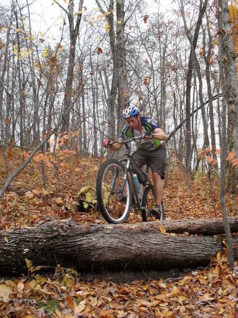
I found myself way in over my head when I came to the off camber rocky section as I was traveling much to quickly for the conditions. I hit the worst possible line and focused on not hurting myself and I made a connection with the rock. Just as I was going to turn and head back up for another try Clay came around the corner and hit the deck in a much more painful manner. No harm no foul and I tried again:
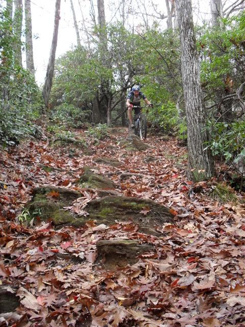
I cannot wrap my head around the Q-bert step on Bennett even though I have seen so many people clean it. I walked and stopped to watch Clay and J’s attempts. Clay bailed with a “not today.” Then J came and I saw him start to nose wheelie just before the top step, not good. As he met the Zenith of his pendulum, I thought for sure some DNA was about to be spread when his huge 200+ form leaped like Catwoman from the bike simultaneously unclipping from the pedals and landing feet down at the bottom of all the steps. It was an impressive save fueled by adrenaline and love for the human form.
On to the overlook, another quick respite and down the rest of Bennett. All of us walked the death defying technical move on Bennett and moved onto Coontree. Coontree is a hoot of a trail and we made it down in quick fashion.
Instead of hiking backup Coontree we decided a loop was in order so onto Horse Cove road up to the Art Loeb trail. I had forgotten how bad any climb up to the Art Loeb is but this one took me to a new place as I made it my mission to keep Clay in site. After what seemed like an eternity we made it to the intersection and I laid down on the knob just relishing the fact that it was over.
Hiking down that beautiful trail to the North Slope connector is painful but it also forces you to take in some nice views. We were rewarded with another attention grabbing decent on North Slope back to the cars. I must remember to pay my respects to the formidable foe, Pisgah. Thanks again for making me feel more alive than I knew I was.
Good ride fellas.
Thursday, October 29, 2009
SPOOOKY, Solo WNDC
Last night was one of the few times in the past few years that none of the regulars were going to show up for the Wednesday night ride. I took that as an option to park somewhere different and take a small little pre-Halloween spook night ride. How can one spook thyself you may ask? Well, park at Corn Mill Shoals and make it your goal to get to the top of Rocky Ridge by sundown.
Its been awhile since I have had the opportunity to ride a route and not ask anyone what they think about this turn or that turn, all I did was turn the pedals over, ride and take in all the electrified air that October provides us with.
I took a hint from the two guys getting out of the Middle Saluda with Kayaks at the turn by “The Best Hotdogs In Town” that the water level was pretty high from the recent rain and that I should stay away from the “wetter” trails at Dupont (i.e. Reasonover, Mine, Airstrip) and it was with that knowledge that I made my turn up Longside headed to Pine Tree.
I must say that Pine Tree is really settling in nice and I find myself really loving the new tread design as I must concentrate to make sure I don’t blow any corners. Even though I only put in one solid day on Pine Tree this year a lot of work has gone into that trail and it turned out fantastic. So here is to faster cornering to anyone who helped with that bad boy this year.
From there I took Sheep Mountain over to Buck Forest, a quick out and back to check out Grassy Falls and up Lake Imaging on over to Jim Branch. I let quite a few bikers ride by while descending Jim Branch and quickly turned into the climb up Ridgeline. I let some fellow trail user’s walk by as they were sitting a top two large beasts and exclaimed their love for October as well as their appreciation for my prompt removal of myself from the trail. I passed two more riders that were climbing Ridgeline with me and reminded myself that I was going to ride Ridgeline in the dark when I knew no one would hinder my descending.
I couldn’t decide if climbing to the top of Rocky Ridge was a good idea or not considering how far it would put me from the car but I reminded myself that I was out for a solo death march and that I needed to go slow down so it was all good.
I was pleasantly surprised to see that I would actually be able to make it to the top by the time the sunset and I was rewarded more than I have been all year on the bike. As I started down Rock Ridge, nature abetted me. I had to stop as it was obvious that with the golden red collage that was encompassing me that I had hit this area of the forest in prime time. It honestly took my breath away.
After the quick respite, I mounted back up and flicked my light on for assistance. I was down Rocky Ridge in a flash and quickly pushing up a mushy Camp Summit. Back over to Ridgeline after dark and my theory proved correct, I met no one while descending another favorite of mine. Ridgeline after dark, I prescribe it to anyone ailing.
After another quick climb up Jim Branch, I knew decisions were on the horizon. Do I climb back up Sheep Mountain or do I challenge the swollen Little River on the Corn Mill Shoals crossing? While descending Lake Imaging to Buck Forest I made a decision, Corn Mill Shoals. When I am by myself, I tend to lean toward loops.
A long spun out section down Corn Mill Shoals let me relax and realize that I was pushing it further than I normally do on a weekday night and it brought a smile as I headed into what is the most comfortable section of the forest for me to navigate. I know the Fawn Lake area of the forest better than I do my own back yard.
Shelter rock to Corn Mill Shoals, I struggled and grunted up the wet steep section and descended the most recent of my trail work in Dupont close to the wall ride. I wondered how high the river would be, could it possibly be higher than the day it caused our WNDC crew to split? Could it be high enough to actually turn me around and cause me to ride an extra two hours? NO WAY, I thought to myself, what’s the worse that could happen, I drown by myself in the middle of the night at Dupont. . . it didn’t seem fitting.
I was surprised as I turned the corner and saw that the river was high enough that it was flowing up to the dirt on the trail and as I looked across the river I could see water splashing on the ledge that is my high water marker. I know that if the water is lower than this rock (just barely today) I can cross with relative ease. Off with the shoes and I was across and in such awe of the forest again that I stopped and took it all in while I fitted my shoes back on.
A quick spin up a wet Corn Mill Shoals and I was back at the car. For the second time in my life I saw some locals letting an animal (opossum?) loose in the Corn Mill Shoals parking lot, the poor guy was obviously frightened and didn’t want to head out into the dark woods alone as it hid in the back of the cage, I understood its uncertainly in a way I couldn’t explain.
Ride on brothers and sisters, ride on.
Good luck to some of the WNDC headed to kick ass in Louisiana this weekend at the 24 Hours of Clear Springs.
Its been awhile since I have had the opportunity to ride a route and not ask anyone what they think about this turn or that turn, all I did was turn the pedals over, ride and take in all the electrified air that October provides us with.
I took a hint from the two guys getting out of the Middle Saluda with Kayaks at the turn by “The Best Hotdogs In Town” that the water level was pretty high from the recent rain and that I should stay away from the “wetter” trails at Dupont (i.e. Reasonover, Mine, Airstrip) and it was with that knowledge that I made my turn up Longside headed to Pine Tree.
I must say that Pine Tree is really settling in nice and I find myself really loving the new tread design as I must concentrate to make sure I don’t blow any corners. Even though I only put in one solid day on Pine Tree this year a lot of work has gone into that trail and it turned out fantastic. So here is to faster cornering to anyone who helped with that bad boy this year.
From there I took Sheep Mountain over to Buck Forest, a quick out and back to check out Grassy Falls and up Lake Imaging on over to Jim Branch. I let quite a few bikers ride by while descending Jim Branch and quickly turned into the climb up Ridgeline. I let some fellow trail user’s walk by as they were sitting a top two large beasts and exclaimed their love for October as well as their appreciation for my prompt removal of myself from the trail. I passed two more riders that were climbing Ridgeline with me and reminded myself that I was going to ride Ridgeline in the dark when I knew no one would hinder my descending.
I couldn’t decide if climbing to the top of Rocky Ridge was a good idea or not considering how far it would put me from the car but I reminded myself that I was out for a solo death march and that I needed to go slow down so it was all good.
I was pleasantly surprised to see that I would actually be able to make it to the top by the time the sunset and I was rewarded more than I have been all year on the bike. As I started down Rock Ridge, nature abetted me. I had to stop as it was obvious that with the golden red collage that was encompassing me that I had hit this area of the forest in prime time. It honestly took my breath away.
After the quick respite, I mounted back up and flicked my light on for assistance. I was down Rocky Ridge in a flash and quickly pushing up a mushy Camp Summit. Back over to Ridgeline after dark and my theory proved correct, I met no one while descending another favorite of mine. Ridgeline after dark, I prescribe it to anyone ailing.
After another quick climb up Jim Branch, I knew decisions were on the horizon. Do I climb back up Sheep Mountain or do I challenge the swollen Little River on the Corn Mill Shoals crossing? While descending Lake Imaging to Buck Forest I made a decision, Corn Mill Shoals. When I am by myself, I tend to lean toward loops.
A long spun out section down Corn Mill Shoals let me relax and realize that I was pushing it further than I normally do on a weekday night and it brought a smile as I headed into what is the most comfortable section of the forest for me to navigate. I know the Fawn Lake area of the forest better than I do my own back yard.
Shelter rock to Corn Mill Shoals, I struggled and grunted up the wet steep section and descended the most recent of my trail work in Dupont close to the wall ride. I wondered how high the river would be, could it possibly be higher than the day it caused our WNDC crew to split? Could it be high enough to actually turn me around and cause me to ride an extra two hours? NO WAY, I thought to myself, what’s the worse that could happen, I drown by myself in the middle of the night at Dupont. . . it didn’t seem fitting.
I was surprised as I turned the corner and saw that the river was high enough that it was flowing up to the dirt on the trail and as I looked across the river I could see water splashing on the ledge that is my high water marker. I know that if the water is lower than this rock (just barely today) I can cross with relative ease. Off with the shoes and I was across and in such awe of the forest again that I stopped and took it all in while I fitted my shoes back on.
A quick spin up a wet Corn Mill Shoals and I was back at the car. For the second time in my life I saw some locals letting an animal (opossum?) loose in the Corn Mill Shoals parking lot, the poor guy was obviously frightened and didn’t want to head out into the dark woods alone as it hid in the back of the cage, I understood its uncertainly in a way I couldn’t explain.
Ride on brothers and sisters, ride on.
Good luck to some of the WNDC headed to kick ass in Louisiana this weekend at the 24 Hours of Clear Springs.
Thursday, September 24, 2009
Wilderness and Impalement
 A sweet Hike with Clay, Duma and Shade from this past weekend. It was my first time this deep into the Shining Rock Wilderness.
Clay and Duma enjoing a quick packless respite.

The rain let up while we wandered around the Six Thousand peak summits so we could enjoy some view.

Shade's enlightenment "Ohhhh This is why they call it Shining Rock Wilderness."


Duma is always making fun of me.


Shade also knows how a well placed cairn can help.


Again Duma was pissed that he couldn't get in my tent so he dug in disgust.

WATCH OUT FOR WOLVES.
Last night was a tough one for the WNDC. I almost impaled myself during a wreck early on. J had a ride ending mechanical 40 feet into the ride. I suffered a tubeless flat and then tried to kill myself coming down Pinnacle Mountain Road. We also crossed some wild rivers which split the group up.
CF and Tomato's route:
Fawn Lake -> Airstrip -> Mine Mountain -> Laurel Ridge -> Shoals -> CMS -> Little River -> Steep Cedar Mountain Side -> Big Rock -> Longside -> Pine Tree -> Sheep Mountain -> Buck Forest -> Conservation -> Johanna -> Pinnacle Mtn Road -> Turkey Knob -> Reasonover
A tough ride for a WNDC!!
Subscribe to:
Posts (Atom)